Sunday, July 4, 2010

Failes Creek Trail, Big Blue Trail and Falls Creek Trail--Uncompahgre Wilderness: 24 miles

4 day/3 Night Backpacking Trip in the Uncompahgre Wilderness

Day 1: Be prepared for a long one! Failes Creek to the Big Blue Trail
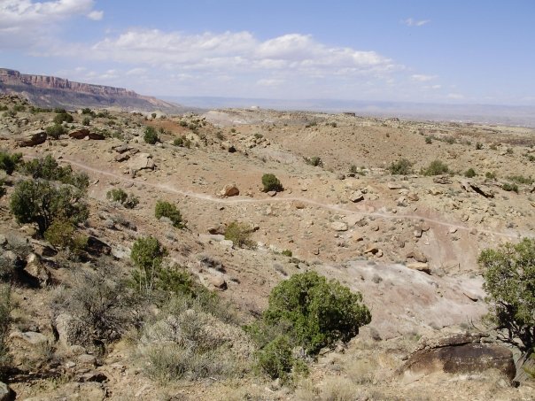
Standing here by the wilderness sign, I've no idea there are 3 more miles, on top of the 7 we've already done, in front of me...


Every adventure has some learning experiences, and this trip was no exception. It was still wonderful and beautiful and I'd do it again. But next time, I'd know a few more things that would help me and the BF out!

Day 1 started off great. We spent the night at the Little Cimmarron campground about 4 miles from the trail head. There were no other campers there and the place was well kept--even had an out house. We started from the Falls Creek area(despite what the sign at the end of the road says, it's 20 miles to here, not 14), heading north/northeast on the Failes Creek trail. Our destination was the Big Blue Trail, 5 miles and 1 ridge away. Failes Creek is a great little trail--mostly wooded with adequate water supplies in the first 2-3 miles. Make sure to have both a GPS and a map and if you are in any doubt about where to go, follow your map! Stay on a north/northeast route and on a trail and you'll be headed the right way.

Once you start climbing the top of the ridge is fairly easy and quick to reach. Coming down seems never ending, and there's no good water on this side, so make sure to load up before heading up the switchbacks. Once you start to hear dirt bikes, you'll know you've reached Big Blue Road and the Alpine Trail. Crossing the creek here is fun, but just aim for the trail marker on the other side and you'll be fine. Take your water shoes!

From here it's a short 1.5 (ish) miles to the Big Blue Trailhead. Our advice, in hindsight, is to camp right near the trail head. By this point you've gone 6.5 or 7 miles and you won't find another campsite for about 3 more. We hiked on in, not knowing any better, and did find a nice spot, but we would have been happier campers if our first day had not been 10 miles of hiking!
This was our campsite for night #1. Those trees across in the center are on the other side of a small ravine--the creek is down a steep trail, but is accessible.

Day Two: Big Blue Continued
Day Two dawned cloudy. We had slept (or at least been in the tent quietly resting in the middle of the night) for almost 12 hours. Coffee and tea were calling us! As we sat on some nice logs looking down at the river below, it started to rain. We dove into the tent just as it started to pour. This was our worst fear...Will this be the day we have to hike all day in the rain?

Karma was on our side however, and about an hour later the sky cleared up and was beautiful for the rest of the day. We made this a short day, considering the length we'd covered the day before, and decided that as soon as we passed Slide Lake, we'd start looking for a spot. Slide Lake is interesting...but the "slide" itself is way more intriguing.

Soon we found a great meadow, complete with easy water access and a waterfall. We had a home. As a bonus, this spot, about 6.5 miles in, had a perfect copse of pine trees for a kitchen. We could sit in this little space, leaned back against a sap-covered tree, and stay dry even in brief rain showers.


Me in the "kitchen" at our camp spot for night #2. There are others just past this and then on for the next 2 miles or so. Lots of great views, water and trees.

Day Three: Big Blue to the Falls Creek Trail

Day three was by far the best day for views on our trip. We left our lovely meadow campsite and headed further up the Big Blue for a day of what we knew would entail quite a bit of climbing. As we climbed, slowly but surely at first, the views opened up before us. We saw great camp sites all along the trail, on the east side of the creek, and wide open meadows and mountains all around us. Soon we turned the corner and there it was: Uncompahgre Peak.


We continued climbing, at some points moving 50 steps forward and stopping, as we got closer to 12,000 ft. The trail is in great shape and is easy to follow (again, it's still helpful to have a map and gps and know where you're going). As soon as we turned onto the Fall Creek Trail (Ridge Stock Driveway heads further south; we turned west) we could see the saddle we were headed for. We took off across the meadow, gaping at the views, for what seemed like forever. There was no reason to complain, the trail was easy to follow, it wasn't too steep, and the views were just incredible. The air was getting thin, however, so we did have to stop a lot. What we should have been doing was eating...

Here's just one of the many views from the summit of our hike on Day #3, at 12, 740 ft.


**A side note: Camp before the summit. Hike in to right below, near the old shack, and camp down there. There is NO good camping on Fall Creek from the junction with Little Cimarron until you're within 3 miles of the end of your trip. If you wait, you'll end up with an 8.5 mile trip and some questionable tent sites...think sliding to the bottom of your tent...digging rocks out of the ground...

We continued on past the summit, heading down to what we thought would be a perfect and soon-to-be-reached campsite. The trail is downhill and covered with rocks. It's pretty slow going just because you have to weave around so many loose rocky spots. We did stop for some snacks, but we pushed ourselves far too hard. This was mostly out of necessity as we couldn't find a spot to camp! Everything was either boggy or uneven or rock infested. We finally did find what turned out to be a great little knoll. It worked for us because we have a small tent and were desperate. After being held captive in our tent for an hour by mosquitoes we were able to come out and enjoy a nice meal of chili mac and camp margaritas before turning in. This campsite is about 1/2 a mile after you cross Fall Creek down in the valley for the first time. If you can hold out for another mile or so, until the next creek crossing, there are great meadows for camping.

Day 4: Fall Creek to the car!


Day #4 was the most beautiful day of all. There were no clouds in the sky and it was too cold for the mosquitoes to be up when we were. At 11,200 ft there were ice crystals in our water at 7 a.m. Still, it was a lovely morning perched on our tiny knoll. We weren't hungry, but we knew we needed to eat, so we ate sesame snaps, a pay day, and cheese. We had gone 50 hours without seeing another soul, but we knew that was all ending soon. We packed up and headed out.

The Fall Creek Trail is great for hiking from this point forward. It's easy to follow, and the views are great. There are some rocky sections with "baby head" rocks to watch for, but it's relatively easy hiking. We enjoyed seeing others along the trail and talked about our newest strategies for our next trip...

* Stop every hour to take OFF the pack, rest, and eat. This will keep you from getting completely hammered. It's better to stop often than to get completely "destination focused" and forget to eat.

* Remember that everything isn't going to go like you think--especially on new trails.

* Falls Creek is not the best trail for camping...a better plan for next time would be: Hike Failes to Big Blue and camp right at the wilderness boundary. Hike up about 7 or 8 miles towards the summit/ridgeline at junction of Big Blue and Fall Creek. Day 3 will be up and over and about 4 miles down Fall Creek past the Little Cimarron Junction...then you have a short hike out on the last day.

* We need another Ursack. Right now we have 1 Ursack (bear proof) and 1 dry bag that we hang with odor-proof bags inside it. We think 2 Ursacks would be better.

So we survived! I only cut myself once, ran into 1 tree limb, came back with 1 horrible pinky-toe blister. It was a great adventure and I'm sure by next year we'll be looking for another one.

Tuesday, June 29, 2010

Taking a Break


In an effort to allow my shin splits and other running aches/pains to dissipate before our backpacking trip (which, for the sake of privacy and theft avoidance we'll just say is "upcoming") I took a break from running. Well, I tried to take a break. I suffered through a 6 a.m. trail run last Tuesday with Lynn and Elissa (not really suffered...it was pleasant once I got over the fact that it was 6 a.m.) and then called a Time Out.

The reason for my Time Out was because I noticed that weight was making my shins hurt more. When I carried my bike downstairs, my shins, which hadn't twinged for days, hurt. When I carried in what must've been 25 lbs of groceries or something, they hurt. So it stood to reason that carrying a 25-30 lb backpack might make them hurt...I wasn't sure, but I also wasn't taking any chances. So, no running. I took 3 days off completely: No running, no hiking, no nothing. Saturday I went out for an early morning hike (wearing the trail runners of course) but it was so hot and the trail so bumpy that I didn't really attempt more than 5 minutes of running. I enjoyed the hike and was able to actually look around at my surroundings instead of straight at the ground!

Sunday I biked Rustler's Loop. Sure it's only about a 45-50 minute ride, but that's enough to get your heart pumping fast and put a grin on your face! I had work to do or else I would have ridden longer. Today I was grumpy. Well, if I'm being honest I was grumpy all weekend, except for when I was biking. I finally had had enough. Still not really willing to risk our trip, I headed home at lunch for a 20 minute walk/run. Hey, 20 minutes was all I had and it was better than nothing!

I really did feel better. Even just 11 minutes of running interspersed with walking felt great. After our trip I'll come back and get started training again for the first of two half marathons: The Mount Sneffels Half Marathon. If you check out the route map, on the hand-drawn map you can click on each mile marker to see what the area looks like there. It's beautiful! I'm SO lucky to get to go run this 13.1 miles...even if I'm next-to-last I won't care because I'll have spent 2+ hours jogging, walking, huffing and puffing, in this beautiful stretch of Colorado. At the end, I hope Lynn and I look like this:


But I"ll probably look more like this:

Sunday, June 20, 2010

Western Rim...a new favorite?

The BF says to me yesterday, "If you could bike anywhere around here tomorrow where would it be?" I said, "Western Rim." Who wouldn't want to spend hours looking at this view?


I think I'm getting comfortable with this trail. Last year I took a bad endo (head over handlebars) off of a ledge right at the start of the gorgeous rim portion and I kind of froze up for the rest of the season. I improved a little, but I was nervous. This year I feel like I'm breaking through every time we bike there. Each time I've ridden something I didn't ride before and I've gotten more at ease with the whole trail.

If you've never been there, the Western Rim trail starts way out in Rabbit Valley by the McDonald Creek Trailhead. You can read some great directions here. When you start out I suggest heading straight over the cattle guard and up the double track Kokopelli Trail. You can follow this all the way to the overlook. You'll save some energy climbing this as opposed to Trail #2 which bears to the right over the cattle guard. Ride the Trail #2 back to the trail head for some awesome downhill!

From the overlook I suggest riding clockwise. You'll hit a huge sandy portion of the trail but after that it's almost all rideable. There are a few hills to push up and maybe a few ledges to walk over/around, but a lot of it is like this:

Fun single track close (but not often scarily close) to the edge of a cliff. You get this for oh 5 or so miles. Here's a challenging but fun little bit on the rim:

I suggest staying far left coming down this!

After that there are 2 hills that will require some pushing by all but the most awesome of awesome riders. Past this is MORE fun downhill over rocks and then you hit the slog...This is me, halfway through the slog:


I'm smiling because I found shade! The 3 miles or so of grinding away at the road takes you back to the overlook where you can bomb down Trail #2 almost all the way back to the car.

IF you decide to check out Western Rim you'll need a high clearance vehicle, or at least a Subaru to get out there ;) I also think, for your virgin Western Rim ride, it's best to have a guide! Happy riding!

Monday, June 14, 2010

Break Throughs

Well the weekend was spent looking out of the windows repeating, "It's still raining!" I won't bore you with the details of that. I will mention that (as seen on FB) I did in fact run 8 miles yesterday. But since I've written 2 posts about running, I'm skipping over most of that as well.


Last week after work the BF and I decided to head out to Lunch Loop for an after-work ride. Lunch Loop is one of the most technical areas for biking and I've struggled for a year with overcoming physical and mental obstacles out there. I assumed this day would be no different. We headed down the main trail and took a right on Pet-Y-kes and huffed and puffed our way up the trail. It was hot. I'd stop and pant and hear my heartbeat in my head...kathump kathump kathump...then I'd go again. The BF was way ahead of me because honestly we just try to get up the hard parts as fast as possible. Who can blame him for riding ahead?

I let a guy pass me and then tried to psych myself up. There was a piece approaching that I never ride. That's not an exaggeration. I've never ridding this. It's a part of the trail where the left side is exposed, and as you come around a curve on the very narrow single track, a big rectangular rock sticks its big ole corner right out into the trail. I'm always afraid I'm going to hit my pedal and go flying off the edge of the trail. For whatever reason this time as I approached it I just kept riding. I didn't look at the rock, I looked at the left edge of the trail. That way i'd be aiming for as far away from the rock as possible. I rode past it and was so excited and focused on that that I didn't make the next obstacle. Still, one obstacle down! I figured if i didn't ride anything else new that day , i didn't care. You can see in the photo above how narrow and exposed the trail is.

From the top of Pet-Y-Kes (after I'd gotten a few bruises and a scrape on some rocks, just to prove I wasn't invincible) we headed left towards the main trail, crossed it, and continued down High Noon. This is the fun part! High Noon is a great connector to the ridge and doesn't require you to climb up to Lemon Squeezer. There are 3 obstacles in a row: The first is a drop which rolls off. It's a big drop, but because it rolls it's doable. Then there is an up-and-over spot that I still have trouble with because I have to pedal up then try to get off the seat and back as far as possible as I go over. Finally there is a craggy, rocky drop between 2 big rocks with a turn at the bottom. I almost made this one before I chickened out that day. Still, I'd never even attempted it before! What was up with my confidence???

Across the ridge we went...easy peasy with just one stop to walk up a ledge. I was talking to myself. "Come on Julie...you can make it down the hill at the end here. You almost did it last time. Just drop the ledge and go. Follow _____ (the BF)." This was the hill in question, from the top:


That's my buddy Andy riding down last year. No fear. A lot of people aim for the left side, then head right halfway down. The BF takes a more straight forward approach. He goes straight down the right side, drops a ledge and cruises to the bottom. No turns, nothing. Just aim straight ahead and go! So that's what I did. I dropped the ledge. By that point I knew he was at the bottom watching. "You got it! You got it!" I could hear him cheering and I knew there was no way I wasn't making it down the hill. I cruised to the bottom like it was nothing! Here's the hill from the bottom:


(That's Andy again. His bro took these last year.) You can see from here the difference in going straight down the biker's right (viewer's left) and going biker's left then right...

As I pulled up beside him he stood there with his mouth hanging open. "That was...amazing. It was beautiful! You looked so calm and in control!" I'm pleased when I accomplish any new trick or obstacle, but at Lunch Loop, well, I'm doubly proud of myself anytime I make it out of there without Life Flight!

Saturday, June 12, 2010

Trail Running


Not the best picture, but not the worst place to get in a good run either. I started trail running because of shin splints. Nasty, tiny knife-like pain in my left shin right above my ankle. Leaving behind the neighborhood roads and heading for the hills (literally) seemed like a good move. It was, it has been. Yesterday the mid-80s temps and cloudy skies made the weather perfect for a trail run. I headed out right after work to Lunch Loop / Tabaguache and decided to run up Eagle's Tail, over to High Noon, then all the way across the ridge and down Kurt's Lane. It's really only about 3 miles, but it's 3 trail miles which, the way I figure it, is at least 4 or 4.5 road miles.

Trails present all kinds of new obstacles: rocks to hop over, sandy or rocky steep hills to crank up or run down, trees to snake past, and of course, bikers and other hikers all on a single track course. The first 20 minutes saw me running for 5 and walking for 2 repeatedly. I told myself if I ran up every hill on this trail I could have all the beer and pasta I wanted afterwards! So I cranked it up all 5 hills on Eagle's Tail and recovered in between. (I'd post a map of the area, but my map is old. Eagle's tail can be found by taking the main Tabaguache trail out to the first intersection, taking a right there towards Pet-Y-Kes and Eagle's, and then taking another right at the next intersection).

Once I was through the hills I only made one more stop on my entire 52 minute route. That was after running up the hill to the top of the ridge and was mostly because I was letting some bikers get ahead of me. The rolling almost-all-downhill section from the ridge top to the parking lot makes for fast time and tricky footwork. Still, you'll never hear me say that I hate running. How could I hate running when the hills and views around me are so amazing? How could I hate it when the whole 52 minutes is spent leaping over and around obstacles, taking my mind off any problems or issues I might have? If you run and you hate it, you should find a new sport. I run and I love it. Even when it hurts.

Today's weather is proving to be difficult for biking. Rain, clouds, rain, clouds...we might actually have to REST for a whole day!

Friday, June 11, 2010

Running vs. Biking

It's a difficult decision these days...do I train for the half-marathon in October by running, or do I mountain bike with the BF and consider it cross-training? Well so far I've managed to do both. I get in two-three runs a week and bike on the days the BF is off. My shins greatly enjoy the biking because it gives them a chance to rest and my ego enjoys the huge strides I've been making as well. I think my biking is improving because my legs are stronger, my endurance better, and my confidence in my abilities is growing too. My running is going well. I've got like 17 weeks to go and I'm up to 8 miles (this weekend anyway) already! I've got tons of time to enjoy my growing endurance in both sports.

My sometimes-running-buddies, Lynn and Elyssa, are super supportive as well. I'm way slower than them and yet when we run together they stop and wait on me. I can text Lynn and give her the breakdown on my run and even if I ran 3 miles in 50 minutes she'd say, "Way to go! You're breathing down my neck!" It's a good thing I have her to keep me motivated some days...my competitive streak comes out and all I want to do is keep up with her on those trails! She'll be hitting her 8 miles on Sunday probably while I'm still at home reading the paper...but then I'll bike with the BF and drink beer and life will be good for us all :)

Still, when I'm doing one, I'm thinking about the other. When I'm trail running I'm thinking which line I'd take if I were on my bike. When I'm biking I occasionally catch myself watching trail runners with envy. (Then of course I hit a technical section and can't think about anything except cleaning the section and then I'm stoked and I forget about everything else). I guess having 2 sport loves is better than no sport loves, but it sure does make it difficult to choose some days!

Monday, May 10, 2010

Cortez/Durango Biking


Who says Grand Junction/Fruita is the only place for good biking on the Western side of the state? I found out this weekend that Cortez and Durango have some awesome bike trails to offer up as well.

On Friday we drove down from our campsite at McPhee Reservoir to Cortez, stopping in Dolores at the Depot for some mighty good breakfast burritos. Yum! Phil's World is just east of town on 160. You'll see the fairgrounds on the right and directly across from that, just past the shooting range, a red road sign that says 30.1. Turn here. You'll see a sign directing you to a dirt parking area .1 mile down the road. The parking lot is on the right and the "start" of Phil's World is across the dirt road from the parking lot.


The cool thing about Phil's World is that you don't even really need a map. You go through a gate and a well-marked path says "start." At every intersection there is a laminated map telling you where you are and where to go. There are also wooden signs labeling every trail. However, if you want a map (and it's always a good idea to have one) they are available in town at the Kokopelli bike shop.

The trail(s) are mostly rolling single track with a few uphill sections. Nothing brutal though. While they aren't the most technically challenging trails, there are a few spots where you get to drop and make your way around rocky outcroppings. Still, it's fun to just pedal and enjoy the downhill and the views!


We did the 8 mile loop which has you heading back to the trail head after Bob's Trail (I think). At the intersection with Adobo you'll head back. The whoop de whoos are unbelievable! SO fast and SO steep, but awesome fun!


On Saturday we headed to the Telegraph Trails in Durango after stopping by the friendly Durango Cyclery shop for some advice. We parked at the Horse Gulch trail head right off of 3rd Ave behind the Sonic. We started biking up the jeep road (a little steering is required) to the Meadow Loop trailhead. From here we headed out the Telegraph Trail, then turned onto Stacy's Loop, followed by Mike's Loop (which has some significant but short lived climbing). After that we headed downhill on a trail that started with a C...so much fun fast downhill I was grinning ear to ear!
The picture at the top is from this set of trails and I must say I'll be back to check those out when the temps hit 100 here!